


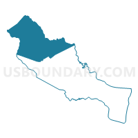
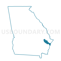
17913 - BUTTON GWINNETT Voting District, Liberty County, Georgia
About
Outline

Summary
| Unique Area Identifier | 562373 |
| Name | 17913 - BUTTON GWINNETT Voting District |
| County | Liberty County |
| State | Georgia |
| Area (square miles) | 185.10 |
| Land Area (square miles) | 167.04 |
| Water Area (square miles) | 18.06 |
| % of Land Area | 90.25 |
| % of Water Area | 9.75 |
| Latitude of the Internal Point | 31.95348090 |
| Longtitude of the Internal Point | -81.63853480 |
Maps

Graphs
Select a template below for downloading or customizing gragh for 17913 - BUTTON GWINNETT Voting District, Liberty County, Georgia


Neighbors
Neighoring Voting District (by Name) Neighboring Voting District on the Map
- 0296 - DANIELSIDING Voting District, Bryan County, GA
- 029FTSTEW - FORT STEWART Voting District, Bryan County, GA
- 1095 - DAISY CITY HALL Voting District, Evans County, GA
- 17911 - LEWIS FRASIER Voting District, Liberty County, GA
- 17912 - LIB CO PRE-K SC Voting District, Liberty County, GA
- 1792 - HINESVILLE Voting District, Liberty County, GA
- 1795 - FLEMING WEST Voting District, Liberty County, GA
- 1796 - FLEMING EAST Voting District, Liberty County, GA
- 1797 - GUM BRANCH Voting District, Liberty County, GA
- 1799 - HINESVILLE LODGE Voting District, Liberty County, GA
- 1831 - BEARDS CREEK Voting District, Long County, GA
- 2676 - BIRDFORD Voting District, Tattnall County, GA
Top 10 Neighboring County Subdivision (by Population) Neighboring County Subdivision on the Map
- Hinesville CCD, Liberty County, GA (52,662)
- Richmond Hill CCD, Bryan County, GA (20,495)
- Glennville CCD, Tattnall County, GA (10,916)
- Midway CCD, Liberty County, GA (8,911)
- Ludowici North CCD, Long County, GA (8,866)
- Claxton CCD, Evans County, GA (7,878)
- Fort Stewart CCD, Bryan County, GA (0)
Top 10 Neighboring Place (by Population) Neighboring Place on the Map
Top 10 Neighboring Unified School District (by Population) Neighboring Unified School District on the Map
- Liberty County School District, GA (54,069)
- Bryan County School District, GA (30,233)
- Long County School District, GA (14,464)
- Fort Stewart School District, GA (9,385)
Top 10 Neighboring State Legislative District Lower Chamber (by Population) Neighboring State Legislative District Lower Chamber on the Map
- State House District 167, GA (61,709)
- State House District 158, GA (57,393)
- State House District 164, GA (53,854)
- State House District 165, GA (49,717)
- State House District 166, GA (46,202)
Top 10 Neighboring State Legislative District Upper Chamber (by Population) Neighboring State Legislative District Upper Chamber on the Map
- State Senate District 1, GA (184,711)
- State Senate District 4, GA (182,797)
- State Senate District 19, GA (161,882)
Top 10 Neighboring 111th Congressional District (by Population) Neighboring 111th Congressional District on the Map
Top 10 Neighboring Census Tract (by Population) Neighboring Census Tract on the Map
- Census Tract 9701, Long County, GA (8,866)
- Census Tract 104, Liberty County, GA (7,278)
- Census Tract 103, Liberty County, GA (6,718)
- Census Tract 101.01, Liberty County, GA (6,221)
- Census Tract 9503, Tattnall County, GA (5,744)
- Census Tract 105.02, Liberty County, GA (5,109)
- Census Tract 102.06, Liberty County, GA (4,509)
- Census Tract 9703, Evans County, GA (3,889)
- Census Tract 101.02, Liberty County, GA (2,297)
- Census Tract 9203.01, Bryan County, GA (1,858)
Top 10 Neighboring 5-Digit ZIP Code Tabulation Area (by Population) Neighboring 5-Digit ZIP Code Tabulation Area on the Map
- 31313, GA (40,302)
- 31324, GA (20,495)
- 30427, GA (12,864)
- 31316, GA (9,749)
- 31315, GA (7,488)
- 31314, GA (1,931)
- 31309, GA (1,210)